
WIKIARCHIVES.SPACE
The Human Spaceflight Archive


Information
- Taken in
- Edwards Air Force Base
- Author
- NASA
- Description
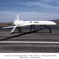
- The snow-capped peak of Mt. San Antonio in the San Gabriel range is visible as the remotely piloted Altus II flies over Southern California’s high desert.
- Created on
- Monday 29 June 1998
- Albums
- US SPACE PROGRAM / AERONAUTICS RESEARCH / Altus
- Source link
- https://www.dfrc.nasa.gov/Gallery/Photo/Altus/index.html
- Visits
- 21
- Rating score
- no rate
- Rate this photo
- License
- Public Domain
- Modified by WikiArchives
- No (original)
- Downloads
- 0
Powered by Piwigo