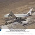
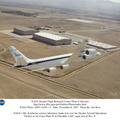
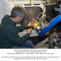
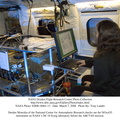
 which is located onboard NASA's DC-8 airborne laboratory. The radar, developed by NASA's Jet Propulsion Laboratory, can penetrate clouds and also collect data at night. Its high-resolution sensors operate at multiple wavelengths and modes, allowing AirSAR to see beneath treetops, through thin sand, and dry snow pack.
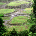
Much of the archaeological evidence needed to understand Pre-Columbian societies in Central America comes from features on the landscape. Difficult terrain and logistics have limited ground data collection.
AirSAR helped to detect signs of ancient civilizations hidden beneath the forest. Its images will shed insights into the way modern humans interact with their landscape, and how ancient peoples lived and what became of their civilizations.")
WIKIARCHIVES.SPACE
The Human Spaceflight Archive
Pre-Columbian archaeological ruins are revealed through Costa Rican rain forest in this photo taken during NASA's AirSAR 2004 Mesoamerica campaign. AirSAR 2004 Mesoamerica is a three-week expedition by an international team of scientists that uses an all-weather imaging tool, called the Airborne Synthetic Aperture Radar (AirSAR) which is located onboard NASA's DC-8 airborne laboratory. The radar, developed by NASA's Jet Propulsion Laboratory, can penetrate clouds and also collect data at night. Its high-resolution sensors operate at multiple wavelengths and modes, allowing AirSAR to see beneath treetops, through thin sand, and dry snow pack.


Information
- Taken in
- Edwards Air Force Base
- Author
- NASA
- Description
-
Pre-Columbian archaeological ruins are revealed through Costa Rican rain forest in this photo taken during NASA's AirSAR 2004 Mesoamerica campaign. AirSAR 2004 Mesoamerica is a three-week expedition by an international team of scientists that uses an all-weather imaging tool, called the Airborne Synthetic Aperture Radar (AirSAR) which is located onboard NASA's DC-8 airborne laboratory. The radar, developed by NASA's Jet Propulsion Laboratory, can penetrate clouds and also collect data at night. Its high-resolution sensors operate at multiple wavelengths and modes, allowing AirSAR to see beneath treetops, through thin sand, and dry snow pack.
Much of the archaeological evidence needed to understand Pre-Columbian societies in Central America comes from features on the landscape. Difficult terrain and logistics have limited ground data collection.
AirSAR helped to detect signs of ancient civilizations hidden beneath the forest. Its images will shed insights into the way modern humans interact with their landscape, and how ancient peoples lived and what became of their civilizations.
- Created on
- Friday 5 March 2004
- Albums
- US SPACE PROGRAM / AERONAUTICS RESEARCH / DC-8
- Source link
- https://www.dfrc.nasa.gov/Gallery/Photo/DC-8/index.html
- Visits
- 13
- Rating score
- no rate
- Rate this photo
- License
- Public Domain
- Modified by WikiArchives
- No (original)
- Downloads
- 0
Powered by Piwigo