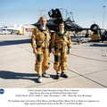
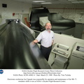
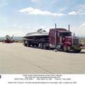
, Edwards, California. NASA operated two of these unique aircraft, an SR-71A and an SR-71B pilot trainer during the decade of the 1990s.
The SR-71 was designed and built by the Lockheed Skunk Works, now Lockheed Martin. Studies have shown that less than 20 percent of the total thrust used to fly at Mach 3 is produced by the basic engine itself. The balance of the total thrust is produced by the unique design of the engine inlet and moveable spike system at the front of the engine nacelles, and by the ejector nozzles at the exhaust.
Data from the SR-71 high speed research program will be used to aid designers of future supersonic/hypersonic aircraft and propulsion systems.")
WIKIARCHIVES.SPACE
The Human Spaceflight Archive
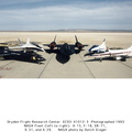
NASA's SR-71A, used for high-speed, high-altitude aeronautical research, is seen here on the ramp outside its main building hangar at the Ames-Dryden Flight Research Facility (later, Dryden Flight Research Center), Edwards, California. NASA operated two of these unique aircraft, an SR-71A and an SR-71B pilot trainer during the decade of the 1990s.


Information
- Taken in
- Edwards Air Force Base
- Author
- NASA
- Description
-
NASA's SR-71A, used for high-speed, high-altitude aeronautical research, is seen here on the ramp outside its main building hangar at the Ames-Dryden Flight Research Facility (later, Dryden Flight Research Center), Edwards, California. NASA operated two of these unique aircraft, an SR-71A and an SR-71B pilot trainer during the decade of the 1990s.
The SR-71 was designed and built by the Lockheed Skunk Works, now Lockheed Martin. Studies have shown that less than 20 percent of the total thrust used to fly at Mach 3 is produced by the basic engine itself. The balance of the total thrust is produced by the unique design of the engine inlet and "moveable spike" system at the front of the engine nacelles, and by the ejector nozzles at the exhaust.
Data from the SR-71 high speed research program will be used to aid designers of future supersonic/hypersonic aircraft and propulsion systems.
- Created on
- Albums
- US SPACE PROGRAM / AERONAUTICS RESEARCH / SR-71
- Source link
- https://www.dfrc.nasa.gov/Gallery/Photo/SR-71/index.html
- Visits
- 8
- Rating score
- no rate
- Rate this photo
- License
- Public Domain
- Modified by WikiArchives
- No (original)
- Downloads
- 0
Powered by Piwigo