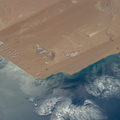
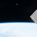
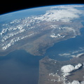
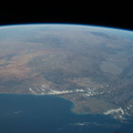
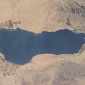
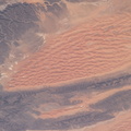
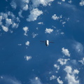
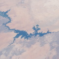
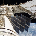
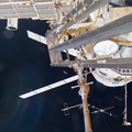
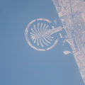
 to the delta. Then the flood water slowly seeps across the 150 kilometer-long delta, supplying forests and wetlands, finally reaching the fault-bounded lower margin of the delta in the middle of winter. Most of the water of this large river is used up by the forests, or evaporates in the dry air. Only two percent of the river's water actually exits the delta. The wetland supports high biodiversity in the middle of the otherwise semiarid Kalahari Desert, and is now one of the most famous tourist sites in Africa. This view also shows the small quantity of water in the Boteti River. Okavango water only reaches the dry lake floors (lower right) in the wettest years. Part of one of the station's solar arrays is visible at right.")
WIKIARCHIVES.SPACE
The Human Spaceflight Archive


Information
- Taken in
- Space
- Author
- NASA
- Description
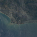
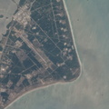
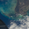
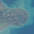
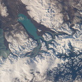
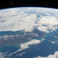
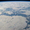
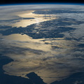
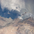
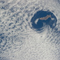
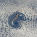
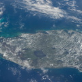
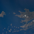
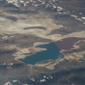
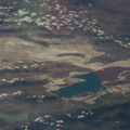
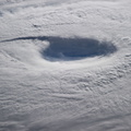
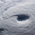
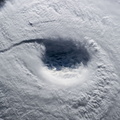
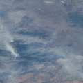
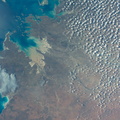
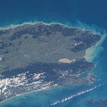
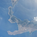
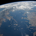
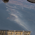
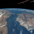
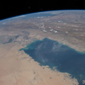
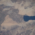
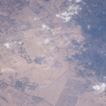
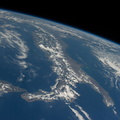
- Okavango inland delta in northern Botswana is featured in this image photographed by an Expedition 40 crew member on the International Space Station. The great Okavango delta in the Kalahari Desert is illuminated in the sun's reflection point in this panorama. Using this sun glint technique, crew members can image fine detail of water bodies. Here the bright line of the Okavango River shows the annual summer flood advancing from the well-watered Angolan Highlands (upper margin) to the delta. Then the flood water slowly seeps across the 150 kilometer-long delta, supplying forests and wetlands, finally reaching the fault-bounded lower margin of the delta in the middle of winter. Most of the water of this large river is used up by the forests, or evaporates in the dry air. Only two percent of the river's water actually exits the delta. The wetland supports high biodiversity in the middle of the otherwise semiarid Kalahari Desert, and is now one of the most famous tourist sites in Africa. This view also shows the small quantity of water in the Boteti River. Okavango water only reaches the dry lake floors (lower right) in the wettest years. Part of one of the station's solar arrays is visible at right.
- Created on
- Friday 6 June 2014
- Albums
- ISS (WIP) / EXPEDITIONS / EXPEDITION 40
- Source link
- https://www.flickr.com/photos/nasa2explore/albums/72157631560566351/
- Visits
- 63
- Rating score
- no rate
- Rate this photo
- License
- CC BY-NC-ND
- Modified by WikiArchives
- No (original)
- Downloads
- 1
EXIF Metadata
NIKON CORPORATION NIKON D3S
- Make
- NIKON CORPORATION
- Model
- NIKON D3S
- DateTimeOriginal
- 2014:06:06 13:54:23
- ApertureFNumber
- f/22.0
Powered by Piwigo