 with a 70mm Hasselblad camera using infrared Aerochrome type 2443 Ektachrome film.")
WIKIARCHIVES.SPACE
The Human Spaceflight Archive


Information
- Taken in
- Space
- Author
- NASA
- Description
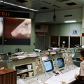
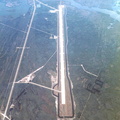
- An infrared, near vertical view of the Chesapeake Bay area showing portions of Virginia, Maryland and Delaware, as photographed from the Apollo spacecraft in Earth orbit during the joint U.S.-USSR Apollo-Soyuz Test Project mission. Richmond and Norfolk can be seen in this picture. Tidewater Virginia covers much of this view. The photograph was taken at an altitude of 217 kilometers (135 statute miles) with a 70mm Hasselblad camera using infrared Aerochrome type 2443 Ektachrome film.
- Created on
- Thursday 24 July 1975
- Albums
- US SPACE PROGRAM / APOLLO / APOLLO SOYUZ ASTP / Mission Photos (Edited)
- Source link
- https://www.flickr.com/photos/nasa2explore/9363124603/in/album-72157634792711526/
- Visits
- 68
- Rating score
- no rate
- Rate this photo
- License
- CC BY-NC
- Modified by WikiArchives
- No (original)
- Downloads
- 2
Powered by Piwigo