WIKIARCHIVES.SPACE
The Human Spaceflight Archive

Information
- Taken in
- Kennedy Space Center
- Author
- NASA/Kim Shiflett
- Description
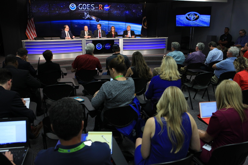
- In the Kennedy Space Center's Press Site auditorium, members of the media participate in a mission briefing on the Geostationary Operational Environmental Satellite (GOES-R). Briefing participants from left are: Sean Potter of NASA Communications; Steven Goodman, NOAA's GOES-R program scientist; Joseph A. Pica, director of the National Weather Service Office of Observations; Sandra Cauffman, deputy director of NASA's Earth Science Division; and Damon Penn, assistant administrator for response at the Federal Emergency Management Agency. GOES-R is the first satellite in a series of next-generation GOES satellites for NOAA, the National Oceanographic and Atmospheric Administration. It will launch to a geostationary orbit over the western hemisphere to provide images of storms and help meteorologists predict severe weather conditionals and develop long-range forecasts
- Created on
- Thursday 17 November 2016
- Albums
- US SPACE PROGRAM / SATELLITES / ATLAS V / GOES-R / Rocket preparation
- Source link
- https://www.flickr.com/photos/nasakennedy/albums/72157669721145354
- Visits
- 19
Location : 28.581239, -80.648933
- Rating score
- no rate
- Rate this photo
- License
- CC BY-NC
- Modified by WikiArchives
- No (original)
- Downloads
- 0
EXIF Metadata
Canon Canon EOS 5D Mark II
- Make
- Canon
- Model
- Canon EOS 5D Mark II
- DateTimeOriginal
- 2016:11:17 14:08:34
- ApertureFNumber
- f/4.5
Powered by Piwigo


