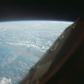
 and the stream and salt flat are inundated. This photograph was taken with a modified 70mm Hasselblad camera, with Eastman Kodak, Ektachrome MS (S.O. 217) color film.")
WIKIARCHIVES.SPACE
The Human Spaceflight Archive


Information
- Taken in
- Space
- Author
- NASA
- Description
- Algeria, south-southeast of the Colomb Bechar area, as seen from the National Aeronautics and Space Administration's Gemini-7 spacecraft. Sand dunes are 200 to 300 feet high in the Grand Erg Occidental area. The Quod Sacura River can be seen in the upper left corner. The white spot in the middle of the picture is the Sebcha el Malah salt beds. It should be noted that the area had just experienced very heavy rains (first in many years) and the stream and salt flat are inundated. This photograph was taken with a modified 70mm Hasselblad camera, with Eastman Kodak, Ektachrome MS (S.O. 217) color film.
- Created on
- Sunday 5 December 1965
- Albums
- US SPACE PROGRAM / GEMINI / GEMINI VII / Mission Photos (Edited)
- Source link
- https://www.flickr.com/photos/nasa2explore/albums/72157635065094289
- Visits
- 76
- Rating score
- no rate
- Rate this photo
- License
- CC BY-NC
- Modified by WikiArchives
- No (original)
- Downloads
- 0
Powered by Piwigo