 can be seen. Lake Tiberias is 14 miles (23 km) long and has a maximum width of 8 miles (13 km). The lake has a maximum depth of 150 feet (46 meters) and covers an area of 64 square miles (165 square km). Lake Tiberias lies 680 feet (207 meters) below sea level and its bed forms part of the Dead Sea Rift Valley. At one time in the geologic past, Lake Tiberias was part of a great inland sea that extended from the Hula marshes in Northern Israel to a point 40 miles (64 km) south of the Dead Sea. The lake is completely encircled by beach, and bordered by escarpments and plains. Tourism and fishing are the main industries around the lake.")
WIKIARCHIVES.SPACE
The Human Spaceflight Archive


Information
- Taken in
- Space
- Author
- NASA
- Description
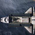
- The third largest city in Israel, the coastal city of Haifa, situated midway between the center and bottom center of the image, is visible in this southeast-looking view. Haifa is the main port of Israel and is the country’s industrial center as well. Major industries include oil refineries, food processing, shipbuilding, chemicals, electrical equipment, steel, and textiles. In the upper left corner of the image, the pear-shaped freshwater Lake Tiberias (Sea of Galilee) can be seen. Lake Tiberias is 14 miles (23 km) long and has a maximum width of 8 miles (13 km). The lake has a maximum depth of 150 feet (46 meters) and covers an area of 64 square miles (165 square km). Lake Tiberias lies 680 feet (207 meters) below sea level and its bed forms part of the Dead Sea Rift Valley. At one time in the geologic past, Lake Tiberias was part of a great inland sea that extended from the Hula marshes in Northern Israel to a point 40 miles (64 km) south of the Dead Sea. The lake is completely encircled by beach, and bordered by escarpments and plains. Tourism and fishing are the main industries around the lake.
- Created on
- Albums
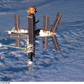
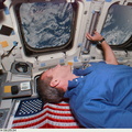
- US SPACE PROGRAM / SPACE SHUTTLE / MISSIONS / STS-79 / Mission Photos (Edited)
- Source link
- https://www.flickr.com/photos/nasa2explore/9360444936/in/album-72157634783073600/
- Visits
- 44
- Rating score
- no rate
- Rate this photo
- License
- CC BY-NC
- Modified by WikiArchives
- No (original)
- Downloads
- 0
Powered by Piwigo