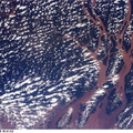
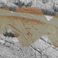
 rafts of the pre-existing crustal material which are similar to those seen in the Conamara Chaos region of Europa.
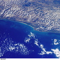
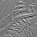
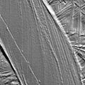
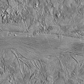
North is to the top of the image and the sun illuminates the surface from the left. The image is in an orthographic projection, centered at 13 degrees north latitude and 110 degrees west longitude, and covers an area approximately 45 by 64 kilometers (28 by 40 miles). The resolution is about 30 meters (100 feet) across. The images were taken on May 31, 1998 at a range of approximately 4200 kilometers (2625 miles) by the Solid State Imaging (SSI) system on NASA's Galileo spacecraft.
The Jet Propulsion Laboratory, Pasadena, CA manages the Galileo mission or NASA's Office of Space Science, Washington, DC.")
WIKIARCHIVES.SPACE
The Human Spaceflight Archive
This mosaic of an area just southeast of the Tyre multi-ring structure on Jupiter's moon Europa combines two sets of images taken by NASA's Galileo spacecraft. Features in this area include pits, plains, and regions of chaotic terrain. The circular to oval shaped pits that contain dark material are secondary craters formed by debris from the Tyre impact. While the origin of the dark material is uncertain, it could be subsurface material that was excavated by impacts or a deposit left behind as surface ice turned to vapor. Two types of plains can be distinguished: lineated and ridged. Ridged plains are composed of numerous small ridges which trend from northwest to southeast while lineated plains appear finer in texture with more closely spaced north to south trending ridges. Two types of chaotic terrain can be distinguished: hummocky and blocky. Hummocky chaos regions appear to contain very fine textured matrix material with a few small "rafts" that are commonly seen in other chaos regions. Blocky chaos regions contain the large (greater than 2 kilometers or 1.25 miles across) "rafts" of the pre-existing crustal material which are similar to those seen in the Conamara Chaos region of Europa.


Information
- Taken in
- Author
- NASA/JPL/ASU
- Description
-
This mosaic of an area just southeast of the Tyre multi-ring structure on Jupiter's moon Europa combines two sets of images taken by NASA's Galileo spacecraft. Features in this area include pits, plains, and regions of chaotic terrain. The circular to oval shaped pits that contain dark material are secondary craters formed by debris from the Tyre impact. While the origin of the dark material is uncertain, it could be subsurface material that was excavated by impacts or a deposit left behind as surface ice turned to vapor. Two types of plains can be distinguished: lineated and ridged. Ridged plains are composed of numerous small ridges which trend from northwest to southeast while lineated plains appear finer in texture with more closely spaced north to south trending ridges. Two types of chaotic terrain can be distinguished: hummocky and blocky. Hummocky chaos regions appear to contain very fine textured matrix material with a few small "rafts" that are commonly seen in other chaos regions. Blocky chaos regions contain the large (greater than 2 kilometers or 1.25 miles across) "rafts" of the pre-existing crustal material which are similar to those seen in the Conamara Chaos region of Europa.
North is to the top of the image and the sun illuminates the surface from the left. The image is in an orthographic projection, centered at 13 degrees north latitude and 110 degrees west longitude, and covers an area approximately 45 by 64 kilometers (28 by 40 miles). The resolution is about 30 meters (100 feet) across. The images were taken on May 31, 1998 at a range of approximately 4200 kilometers (2625 miles) by the Solid State Imaging (SSI) system on NASA's Galileo spacecraft.
The Jet Propulsion Laboratory, Pasadena, CA manages the Galileo mission or NASA's Office of Space Science, Washington, DC.
- Created on
- Monday 7 December 1998
- Albums
- US SPACE PROGRAM / PROBES / JUPITER / GALILEO / Mission Photos (Edited) / JUPITER / EUROPA
- Source link
- https://photojournal.jpl.nasa.gov
- Visits
- 15
- Rating score
- no rate
- Rate this photo
- License
- Public Domain
- Modified by WikiArchives
- No (original)
- Downloads
- 1
Powered by Piwigo