
WIKIARCHIVES.SPACE
The Human Spaceflight Archive

Information
- Taken in
- Vandenberg
- Author
- USSF 30th Space Wing
- Description
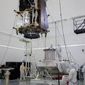
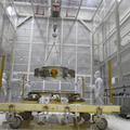
- Technicians monitor the progress as a crane is used to lift the secondary payload adapter for NASA’s Landsat 9 mission onto a transporter stand at Vandenberg Space Force Base in California, on Aug. 4, 2021. The payload adapter will be transported to the Integrated Processing Facility. Several secondary payloads, called CubeSats, will launch with Landsat 9 atop a United Launch Alliance Atlas V rocket from Vandenberg in September 2021. The launch is being managed by NASA’s Launch Services Program based at Kennedy Space Center, America’s multi-user spaceport. The Landsat 9 satellite will continue the nearly 50-year legacy of previous Landsat missions. It will monitor key natural and economic resources from orbit. Landsat 9 is managed by the agency’s Goddard Space Flight Center in Greenbelt, Maryland. The satellite will carry two instruments: the Operational Land Imager 2, which collects images of Earth’s landscapes in visible, near infrared and shortwave infrared light, and the Thermal Infrared Sensor 2, which measures the temperature of land surfaces. Like its predecessors, Landsat 9 is a joint mission between NASA and the U.S. Geological Survey.
- Created on
- Wednesday 4 August 2021
- Albums
- US SPACE PROGRAM / SATELLITES / ATLAS V / LANDSAT 9 / Rocket preparation
- Source link
- https://www.flickr.com/photos/nasakennedy/albums/72157719454254597
- Visits
- 31
- Rating score
- no rate
- Rate this photo
- License
- CC BY-NC-ND
- Modified by WikiArchives
- No (original)
- Downloads
- 0
EXIF Metadata
NIKON CORPORATION NIKON D850
- Make
- NIKON CORPORATION
- Model
- NIKON D850
- DateTimeOriginal
- 2021:08:04 14:17:11
- ApertureFNumber
- f/4.0
Powered by Piwigo