 Delta II rocket. NASA's Ice, Cloud and land Elevation Satellite-2 (ICESat-2) is scheduled to launch on the final ULA Delta II rocket later this year. ICESat-2 will measure the height of a changing Earth, one laser pulse at a time, 10,000 laser pulses a second. The satellite will carry a single instrument, the Advanced Topographic Laser Altimeter System. ICESat-2 will help scientists investigate why, and how much our planet's frozen and icy areas, called the cryosphere, is changing in a warming climate.")
WIKIARCHIVES.SPACE
The Human Spaceflight Archive


Information
- Taken in
- Vandenberg
- Autor
- NASA/Randy Beaudoin
- Descripció
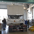
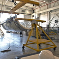
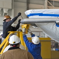
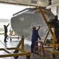
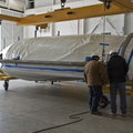
- Inside Building 836 at Vandenberg Air Force Base in California, the top of the shipping container is lifted up from the payload fairings for the United Launch Alliance (ULA) Delta II rocket. NASA's Ice, Cloud and land Elevation Satellite-2 (ICESat-2) is scheduled to launch on the final ULA Delta II rocket later this year. ICESat-2 will measure the height of a changing Earth, one laser pulse at a time, 10,000 laser pulses a second. The satellite will carry a single instrument, the Advanced Topographic Laser Altimeter System. ICESat-2 will help scientists investigate why, and how much our planet's frozen and icy areas, called the cryosphere, is changing in a warming climate.
- Creada el
- Dijous 22 Febrer 2018
- Àlbums
- US SPACE PROGRAM / SATELLITES / DELTA II / ICESat-2 / Rocket preparation
- Source link
- https://www.flickr.com/photos/nasakennedy/albums/72157694494384695/page1
- Visites
- 33
- Puntuació
- sense valorar
- Valoreu aquesta foto
- License
- CC BY-NC-ND
- Modified by WikiArchives
- No (original)
- Descàrregues
- 1
Metadades EXIF
NIKON CORPORATION NIKON D7100
- Make
- NIKON CORPORATION
- Model
- NIKON D7100
- DateTimeOriginal
- 2018:02:22 09:06:39
- ApertureFNumber
- f/7.1
Desenvolupat per Piwigo