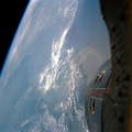
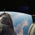
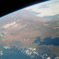
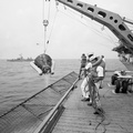
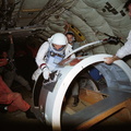
, Chile (top center) and Bolivia as seen from the Gemini-9 spacecraft during its 35th revolution of Earth. The large body of water at lower right is Lake Titicaca. The smaller lake at left edge is Lake Poopo. Salar de Uyuni is the large light-colored area at upper left. At the bottom of the picture is the snow-capped Cordillera Real range of the Andes Mountains. The Pacific coastline of Peru and Chile is at upper right. The range running parallel with the coastline is the Cordillera Occidental. The image was taken with a modified 70mm Hasselblad camera, using Eastman Kodak, Ektachrome MS (S.O. 217) color film.")
WIKIARCHIVES.SPACE
The Human Spaceflight Archive


Information
- Taken in
- Space
- Author
- NASA
- Description
- Areas of Peru (upper right), Chile (top center) and Bolivia as seen from the Gemini-9 spacecraft during its 35th revolution of Earth. The large body of water at lower right is Lake Titicaca. The smaller lake at left edge is Lake Poopo. Salar de Uyuni is the large light-colored area at upper left. At the bottom of the picture is the snow-capped Cordillera Real range of the Andes Mountains. The Pacific coastline of Peru and Chile is at upper right. The range running parallel with the coastline is the Cordillera Occidental. The image was taken with a modified 70mm Hasselblad camera, using Eastman Kodak, Ektachrome MS (S.O. 217) color film.
- Created on
- Sunday 5 June 1966
- Albums
- US SPACE PROGRAM / GEMINI / GEMINI IX / Mission Photos (Edited)
- Source link
- https://www.flickr.com/photos/nasa2explore/albums/72157634789297169
- Visits
- 79
- Rating score
- no rate
- Rate this photo
- License
- CC BY-NC
- Modified by WikiArchives
- No (original)
- Downloads
- 1
Powered by Piwigo