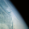
 trending east-west.")
WIKIARCHIVES.SPACE
The Human Spaceflight Archive


Information
- Taken in
- Space
- Author
- NASA
- Description
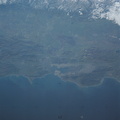
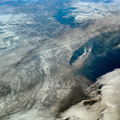
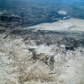
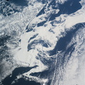
- An oblique view of a portion of the northeastern part of the United States, as photographed from the Skylab space station in Earth orbit by one of the Skylab 4 crewmen. The camera used was a hand-held 70mm Hasselblad, and with SO-368 medium-speed Ektachrome film. This is an excellent example of the regional view which is available from space. The entire area of New Jersey, eastern Pennsylvania, southeastern New York, and southern New England can be examined in one view. Long Island, New York City and the lower Hudson River Valley are readily seen in their regional framework. The Boston area, although blurred by clouds, is also included. The spackling of the snow enhances the contrast, especially of terrain and cultural features. Different levels of clouds can be studies, especially the crossing layers of cirrus in the center of the photograph, with the lower cirrus trending north-south and the upper (probably associated with a jet stream) trending east-west.
- Created on
- Saturday 5 January 1974
- Albums
- US SPACE PROGRAM / SKYLAB / SKYLAB 4 / Mission Photos (Original)
- Source link
- https://www.flickr.com/photos/nasa2explore/albums/72157638838227374
- Visits
- 97
- Rating score
- no rate
- Rate this photo
- License
- CC BY-NC
- Modified by WikiArchives
- No (original)
- Downloads
- 0
Powered by Piwigo