 spacecraft is lifted up the launch service tower. The fairing will be placed around the spacecraft to protect it during launch. The NOAA-N satellite will be placed into a polar orbit aboard a Boeing Delta 2 rocket. The spacecraft will continue to provide a polar-orbiting platform to support (1) environmental monitoring instruments for imaging and measuring the Earth's atmosphere, its surface, and cloud cover, including Earth radiation, atmospheric ozone, aerosol distribution, sea surface temperature, and vertical temperature and water profiles in the troposphere and stratosphere; (2) measurement of proton and electron flux at orbit altitude; (3) data collection from remote platforms; and (4) the Search and Rescue Satellite-Aided Tracking (SARSAT) system. Additionally, NOAA-N is the fourth in the series of support dedicated microwave instruments for the generation of temperature, moisture, surface, and hydrological products in cloudy regions where visible and infrared (IR) instruments have decreased capability. Launch is currently scheduled for no earlier than May 11, 2005.")
WIKIARCHIVES.SPACE
The Human Spaceflight Archive
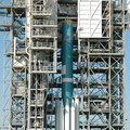
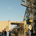
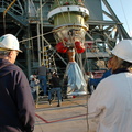
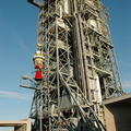
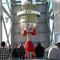
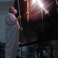
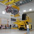
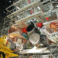
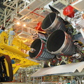
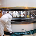
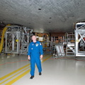
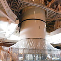
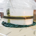
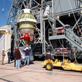
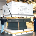
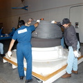
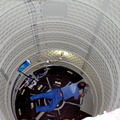
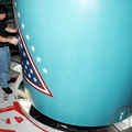
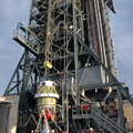
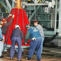
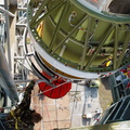
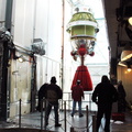
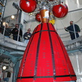
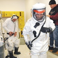
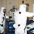
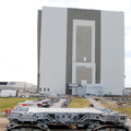
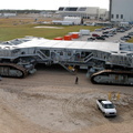
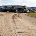
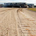
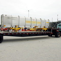
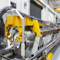
On Space Launch Complex 2 at Vandenberg Air Force Base in California, one-half of the fairing for the National Oceanic and Atmospheric Administration (NOAA-N) spacecraft is lifted up the launch service tower. The fairing will be placed around the spacecraft to protect it during launch. The NOAA-N satellite will be placed into a polar orbit aboard a Boeing Delta 2 rocket. The spacecraft will continue to provide a polar-orbiting platform to support (1) environmental monitoring instruments for imaging and measuring the Earth's atmosphere, its surface, and cloud cover, including Earth radiation, atmospheric ozone, aerosol distribution, sea surface temperature, and vertical temperature and water profiles in the troposphere and stratosphere; (2) measurement of proton and electron flux at orbit altitude; (3) data collection from remote platforms; and (4) the Search and Rescue Satellite-Aided Tracking (SARSAT) system. Additionally, NOAA-N is the fourth in the series of support dedicated microwave instruments for the generation of temperature, moisture, surface, and hydrological products in cloudy regions where visible and infrared (IR) instruments have decreased capability. Launch is currently scheduled for no earlier than May 11, 2005.


Information
- Taken in
- Vandenberg
- Author
- NASA
- Description
-
On Space Launch Complex 2 at Vandenberg Air Force Base in California, one-half of the fairing for the National Oceanic and Atmospheric Administration (NOAA-N) spacecraft is lifted up the launch service tower. The fairing will be placed around the spacecraft to protect it during launch. The NOAA-N satellite will be placed into a polar orbit aboard a Boeing Delta 2 rocket. The spacecraft will continue to provide a polar-orbiting platform to support (1) environmental monitoring instruments for imaging and measuring the Earth's atmosphere, its surface, and cloud cover, including Earth radiation, atmospheric ozone, aerosol distribution, sea surface temperature, and vertical temperature and water profiles in the troposphere and stratosphere; (2) measurement of proton and electron flux at orbit altitude; (3) data collection from remote platforms; and (4) the Search and Rescue Satellite-Aided Tracking (SARSAT) system. Additionally, NOAA-N is the fourth in the series of support dedicated microwave instruments for the generation of temperature, moisture, surface, and hydrological products in cloudy regions where visible and infrared (IR) instruments have decreased capability. Launch is currently scheduled for no earlier than May 11, 2005.
- Created on
- Friday 17 December 2004
- Albums
- US SPACE PROGRAM / SATELLITES / DELTA II / NOAA-N / Rocket preparation
- Source link
- https://science.ksc.nasa.gov/gallery/photos/2005/
- Visits
- 27
- Rating score
- no rate
- Rate this photo
- License
- CC BY-NC-ND
- Modified by WikiArchives
- No (original)
- Downloads
- 0
Powered by Piwigo