 where it will be lifted to vertical and mated to the external tank and solid rocket boosters in high bay 1. Space Shuttle Endeavour is targeted for launch on mission STS-99 Jan. 13, 2000 at 1:11 p.m. EST. STS-99 is the Shuttle Radar Topography Mission, an international project spearheaded by the National Imagery and Mapping Agency and NASA, with participation of the German Aerospace Center DLR. The SRTM consists of a specially modified radar system that will gather data for the most accurate and complete topographic map of the Earth's surface that has ever been assembled. SRTM will make use of radar interferometry, wherein two radar images are taken from slightly different locations. Differences between these images allow for the calculation of surface elevation, or change. The SRTM hardware will consist of one radar antenna in the shuttle payload bay and a second radar antenna attached to the end of a mast extended 60 meters (195 feet) out from the shuttle.")
WIKIARCHIVES.SPACE
The Human Spaceflight Archive


Information
- Taken in
- Kennedy Space Center
- Author
- NASA
- Description
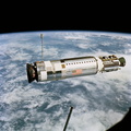
- Orbiter Endeavour aims its nose toward the Vehicle Assembly Building (left) where it will be lifted to vertical and mated to the external tank and solid rocket boosters in high bay 1. Space Shuttle Endeavour is targeted for launch on mission STS-99 Jan. 13, 2000 at 1:11 p.m. EST. STS-99 is the Shuttle Radar Topography Mission, an international project spearheaded by the National Imagery and Mapping Agency and NASA, with participation of the German Aerospace Center DLR. The SRTM consists of a specially modified radar system that will gather data for the most accurate and complete topographic map of the Earth's surface that has ever been assembled. SRTM will make use of radar interferometry, wherein two radar images are taken from slightly different locations. Differences between these images allow for the calculation of surface elevation, or change. The SRTM hardware will consist of one radar antenna in the shuttle payload bay and a second radar antenna attached to the end of a mast extended 60 meters (195 feet) out from the shuttle.
- Created on
- Thursday 2 December 1999
- Source link
- https://science.ksc.nasa.gov/gallery/photos/1999/
- Visits
- 100
- Rating score
- no rate
- Rate this photo
- License
- CC BY-NC-ND
- Modified by WikiArchives
- No (original)
- Downloads
- 0
Powered by Piwigo