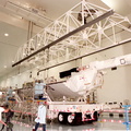
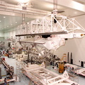
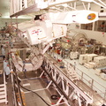
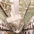
 in the Space Station Processing Facility, the Shuttle Radar Topography Mission (SRTM) moves across the floor toward a workstand. The SRTM, which is the primary payload on mission STS-99, consists of a specially modified radar system that will fly onboard the Space Shuttle during the 11-day mission scheduled for launch in September 1999. The objective of this radar system is to obtain the most complete high-resolution digital topographic database of the Earth. It will gather data that will result in the most accurate and complete topographic map of the Earth's surface that has ever been assembled. SRTM is an international project spearheaded by the National Imagery and Mapping Agency and NASA, with participation of the German Aerospace Center DLR. SRTM will be making use of a technique called radar interferometry, wherein two radar images are taken from slightly different locations. Differences between these images allow for the calculation of surface elevation, or change. To get two radar images taken from different locations, the SRTM hardware will consist of one radar antenna in the shuttle payload bay and a second radar antenna attached to the end of a mast extended 60 meters (195 feet) out from the shuttle.")
WIKIARCHIVES.SPACE
The Human Spaceflight Archive


Information
- Taken in
- Kennedy Space Center
- Зураг авсан
- NASA
- Тайлбар
- After being lifted off the transporter (lower right) in the Space Station Processing Facility, the Shuttle Radar Topography Mission (SRTM) moves across the floor toward a workstand. The SRTM, which is the primary payload on mission STS-99, consists of a specially modified radar system that will fly onboard the Space Shuttle during the 11-day mission scheduled for launch in September 1999. The objective of this radar system is to obtain the most complete high-resolution digital topographic database of the Earth. It will gather data that will result in the most accurate and complete topographic map of the Earth's surface that has ever been assembled. SRTM is an international project spearheaded by the National Imagery and Mapping Agency and NASA, with participation of the German Aerospace Center DLR. SRTM will be making use of a technique called radar interferometry, wherein two radar images are taken from slightly different locations. Differences between these images allow for the calculation of surface elevation, or change. To get two radar images taken from different locations, the SRTM hardware will consist of one radar antenna in the shuttle payload bay and a second radar antenna attached to the end of a mast extended 60 meters (195 feet) out from the shuttle.
- Үүсгэсэн огноо
- Пүрэв 13 5-р сар 1999
- Source link
- https://science.ksc.nasa.gov/gallery/photos/1999/
- Үзсэн
- 65
- Үнэлгээ оноо
- үнэлгээ байхгүй
- Үнэлэх
- License
- CC BY-NC-ND
- Modified by WikiArchives
- No (original)
- Downloads
- 0
Вэб хөгжүүлэгч Piwigo