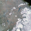
. At 11:30 a.m. (EST) when this picture was made the Apollo 9 spacecraft was at an altitude of 119 nautical miles, and the sun elevation was 38 degrees above the horizon. The location of the point on Earth's surface at which the four-camera combination was aimed was 33 degrees 42 minutes north latitude, and 103 degrees 1 minute west longitude. The other three cameras used: (B) black and white film with a red filter; (C) black and white infrared film; and (D) black and white film with a green filter.")
WIKIARCHIVES.SPACE
The Human Spaceflight Archive


Information
- Taken in
- Space
- Аутор
- NASA
- Опис
- Color infrared photograph of the Texas-New Mexico border area, between Lubbock and Roswell, taken on March 12, 1969, by one of the four synchronized cameras of the Apollo 9 Earth Resources Survey (SO65). At 11:30 a.m. (EST) when this picture was made the Apollo 9 spacecraft was at an altitude of 119 nautical miles, and the sun elevation was 38 degrees above the horizon. The location of the point on Earth's surface at which the four-camera combination was aimed was 33 degrees 42 minutes north latitude, and 103 degrees 1 minute west longitude. The other three cameras used: (B) black and white film with a red filter; (C) black and white infrared film; and (D) black and white film with a green filter.
- Датум израде:
- Среда 12 Март 1969
- Категорије
- US SPACE PROGRAM / APOLLO / APOLLO 9 / Mission Photos (Edited)
- Source link
- https://www.flickr.com/photos/nasa2explore/9349131325/in/album-72157634765433538/
- Посета
- 112
- Оцена резултата
- без оцене
- Оцени ову слику
- License
- Public Domain
- Modified by WikiArchives
- No (original)
- Преузимања
- 1
Урађено у Piwigo