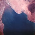
. Lake Rkiz is to the left of the river in Mauritania. The Trarza Scrub Hills, a large area of elongated, fixed dunes, is in the lower left of the print. The land area seen in this photo is approximately 10,000 square miles or about the size of the state of Maryland. The photo was made one hour and fifty minutes after liftoff using a J.A. Maurer model 220G camera with Eastman Kodak SO-121 high resolution aerial Ektachrome film (exposure setting of f: 5.6 at 1/500 sec.).")
WIKIARCHIVES.SPACE
The Human Spaceflight Archive


Information
- Taken in
- Space
- Author
- NASA
- Description
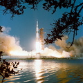
- During the second revolution of the National Aeronautics and Space Administration's Apollo 6 spacecraft, this photograph of Senegal and Mauritania was taken at an altitude of 125 nautical miles. The predominant feature is the valley of the Senegal River (flowing to lower right). Lake Rkiz is to the left of the river in Mauritania. The Trarza Scrub Hills, a large area of elongated, fixed dunes, is in the lower left of the print. The land area seen in this photo is approximately 10,000 square miles or about the size of the state of Maryland. The photo was made one hour and fifty minutes after liftoff using a J.A. Maurer model 220G camera with Eastman Kodak SO-121 high resolution aerial Ektachrome film (exposure setting of f: 5.6 at 1/500 sec.).
- Created on
- Thursday 4 April 1968
- Albums
- US SPACE PROGRAM / APOLLO / APOLLO 6 / Mission Photos (Edited)
- Source link
- https://www.flickr.com/photos/nasa2explore/9347341100/in/album-72157634749388057/
- Visits
- 170
- Rating score
- no rate
- Rate this photo
- License
- Public Domain
- Modified by WikiArchives
- No (original)
- Downloads
- 0
Powered by Piwigo