 by 45-kilometer (27-mile) region near Hestia Rupes on the northwestern corner of Aphrodite Terra. The complex network of narrow (")
WIKIARCHIVES.SPACE
The Human Spaceflight Archive


Information
- Taken in
- Author
- NASA/JPL-Caltech
- Description
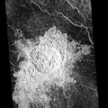
- This is a Magellan radar image covering a 105- kilometer (63-mile) by 45-kilometer (27-mile) region near Hestia Rupes on the northwestern corner of Aphrodite Terra. The complex network of narrow (<1 kilometer) fractures in the center of the image extends for approximately 50 kilometers (31 miles). This network exhibits tributary-like branches similar to those observed in river systems on Earth. However, the angular intersections of tributaries suggest tectonic control. These features appear to be due to drainage of lava along preexisting fractures and subsequent collapse of the surface. The underlying tectonic fabric can be observed in the northeast trending ridges which predate the plains.
- Created on
- Wednesday 23 October 1996
- Albums
- US SPACE PROGRAM / PROBES / VENUS / MAGELLAN / Mission Photos (Edited)
- Source link
- https://photojournal.jpl.nasa.gov
- Visits
- 17
- Rating score
- no rate
- Rate this photo
- License
- Public Domain
- Modified by WikiArchives
- No (original)
- Downloads
- 0
Powered by Piwigo