 should be about 5 centimeters (2 inches) apart when viewing. This area is located at 38.4 degrees south latitude and 78.3 degrees east longitude. The incidence, or look, angle of the left image is 28.5 degrees and that of the right image is 15.6 degrees. Radar illumination for both images comes from the left. A small dome at left center is about 140 meters (464 feet) high and 6 kilometers (3.7 miles) wide. Other domes with smaller relief can be perceived in three dimensions. At the smaller incidence angle used to acquire the image on the right, radar brightness is more sensitive to small changes in topography. This enhances the visibility of many of the domes in this scene.")
WIKIARCHIVES.SPACE
The Human Spaceflight Archive


Information
- Taken in
- Author
- NASA/JPL-Caltech
- Description
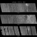
- This Magellan image depicts a stereoscopic pair of an area on Venus with small volcanic domes. Stereoscopic images of Venus offer exciting new possibilities for scientific analysis of Venusian landforms, such as the domes shown here, impact craters, graben -- long rifts bounded by faults -- and other geologic features. Stereopsis, or a three-dimensional view of this scene, may be obtained by viewing with a stereoscope. One may also cut this photograph into two parts and look at the left image with the left eye and the right image with the right eye; conjugate images (the same features) should be about 5 centimeters (2 inches) apart when viewing. This area is located at 38.4 degrees south latitude and 78.3 degrees east longitude. The incidence, or look, angle of the left image is 28.5 degrees and that of the right image is 15.6 degrees. Radar illumination for both images comes from the left. A small dome at left center is about 140 meters (464 feet) high and 6 kilometers (3.7 miles) wide. Other domes with smaller relief can be perceived in three dimensions. At the smaller incidence angle used to acquire the image on the right, radar brightness is more sensitive to small changes in topography. This enhances the visibility of many of the domes in this scene.
- Created on
- Thursday 14 March 1996
- Albums
- US SPACE PROGRAM / PROBES / VENUS / MAGELLAN / Mission Photos (Edited)
- Source link
- https://photojournal.jpl.nasa.gov
- Visits
- 16
- Rating score
- no rate
- Rate this photo
- License
- Public Domain
- Modified by WikiArchives
- No (original)
- Downloads
- 0
Powered by Piwigo