 and Maat Mons (latitude 0 degree, longitude 195 degrees).
This is a three-dimensional perspective view of Venusian Terrains composed of reduced resolution left-looking synthetic-aperture radar images merged with altimetry data from the Magellan spacecraft.")
WIKIARCHIVES.SPACE
The Human Spaceflight Archive
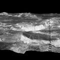
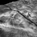
The view is a close-up of Atete Corona, a 600-km-long and 450-km-wide feature at latitude 16 degrees S., longitude 244 degrees; looking north. Coronae are roughly circular volcanic features believed to form over hot upwellings of magma within the Venusian mantle. The north end of the corona bounds Parga Chasma, a 0-3 km deep depression that spans 1,870 km connecting Themis Regio (latitude 35 degrees S., longitude 285 degrees) and Maat Mons (latitude 0 degree, longitude 195 degrees).


Information
- Taken in
- Author
- NASA/JPL/USGS
- Description
-
The view is a close-up of Atete Corona, a 600-km-long and 450-km-wide feature at latitude 16 degrees S., longitude 244 degrees; looking north. Coronae are roughly circular volcanic features believed to form over hot upwellings of magma within the Venusian mantle. The north end of the corona bounds Parga Chasma, a 0-3 km deep depression that spans 1,870 km connecting Themis Regio (latitude 35 degrees S., longitude 285 degrees) and Maat Mons (latitude 0 degree, longitude 195 degrees).
This is a three-dimensional perspective view of Venusian Terrains composed of reduced resolution left-looking synthetic-aperture radar images merged with altimetry data from the Magellan spacecraft.
- Created on
- Wednesday 3 June 1998
- Albums
- US SPACE PROGRAM / PROBES / VENUS / MAGELLAN / Annoted/Science
- Source link
- https://photojournal.jpl.nasa.gov
- Visits
- 18
- Rating score
- no rate
- Rate this photo
- License
- Public Domain
- Modified by WikiArchives
- No (original)
- Downloads
- 0
Powered by Piwigo