.
The Phoenix Mission is led by the University of Arizona, Tucson, on behalf of NASA. Project management of the mission is by NASA's Jet Propulsion Laboratory, Pasadena, Calif. Spacecraft development is by Lockheed Martin Space Systems, Denver.
Photojournal Note: As planned, the Phoenix lander, which landed May 25, 2008 23:53 UTC, ended communications in November 2008, about six months after landing, when its solar panels ceased operating in the dark Martian winter.")
WIKIARCHIVES.SPACE
The Human Spaceflight Archive
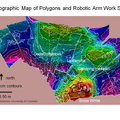
This map shows a color-coded interpretation of geomorphic units—categories based on surface textures and contours—in the region where NASA's Phoenix Mars Lander has studied an arctic Martian plain. It covers an area about 65 kilometers by 65 kilometers (40 miles by 40 miles).


Information
- Taken in
- 작성자
- NASA/JPL/University of Arizona
- Description
-
This map shows a color-coded interpretation of geomorphic units—categories based on surface textures and contours—in the region where NASA's Phoenix Mars Lander has studied an arctic Martian plain. It covers an area about 65 kilometers by 65 kilometers (40 miles by 40 miles).
The Phoenix Mission is led by the University of Arizona, Tucson, on behalf of NASA. Project management of the mission is by NASA's Jet Propulsion Laboratory, Pasadena, Calif. Spacecraft development is by Lockheed Martin Space Systems, Denver.
Photojournal Note: As planned, the Phoenix lander, which landed May 25, 2008 23:53 UTC, ended communications in November 2008, about six months after landing, when its solar panels ceased operating in the dark Martian winter.
- 생성일
- 월요일 15 12월 2008
- 앨범
- US SPACE PROGRAM / PROBES / MARS / PHOENIX / Annoted/Science
- Source link
- https://photojournal.jpl.nasa.gov
- 방문자
- 24
- 평점
- 평점 없음
- 이 사진 평가
- License
- Public Domain
- Modified by WikiArchives
- No (original)
- 다운로드
- 1
Powered by Piwigo