, MESSENGER became the first spacecraft ever to orbit the planet Mercury. The mission is currently in its commissioning phase, during which spacecraft and instrument performance are verified through a series of specially designed checkout activities. In the course of the one-year primary mission, the spacecraft's seven scientific instruments and radio science investigation will unravel the history and evolution of the Solar System's innermost planet. Visit the Why Mercury? section of this website to learn more about the science questions that the MESSENGER mission has set out to answer.
Date acquired: March 30, 2011
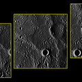
Image Mission Elapsed Time (MET): 209939337, 209939352, 209939367
Image ID: 67333, 67341, 67349
Instrument: Wide Angle Camera (WAC) of the Mercury Dual Imaging System (MDIS)
WAC filter: 7 (748 nanometers)
Center Latitude (67341): 80.1° N
Center Longitude (67341): 62.1° E
Resolution: 350 meters/pixel
Scale: Each frame is about 85 kilometers (53 miles) across")
WIKIARCHIVES.SPACE
The Human Spaceflight Archive
These three images are of Mercury's far-northern "Arctic" region, skirting the 80° N latitude circle, and bring us a glimpse of territory not previously imaged by spacecraft. MESSENGER engineering , instrument, operations, and science teams are checking the performance of the spacecraft and science instruments in the challenging environment in orbit around the planet closest to the Sun. These images and others collected during this "commissioning period" afford an opportunity to test our ability to mosaic overlapping images. These three images were binned on the spacecraft from their original 1024 x 1024 pixel size to 256 x 256. This type of image compression helps to reduce the amount of data that must be downlinked across interplanetary space from MESSENGER to the Deep Space Network on Earth. The images here are not map projected but have been rotated so that north is approximately toward the top.

Information
- Taken in
- Author
- NASA/Johns Hopkins University Applied Physics Laboratory/Carnegie Institution of Washington
- Description
-
These three images are of Mercury's far-northern "Arctic" region, skirting the 80° N latitude circle, and bring us a glimpse of territory not previously imaged by spacecraft. MESSENGER engineering , instrument, operations, and science teams are checking the performance of the spacecraft and science instruments in the challenging environment in orbit around the planet closest to the Sun. These images and others collected during this "commissioning period" afford an opportunity to test our ability to mosaic overlapping images. These three images were binned on the spacecraft from their original 1024 x 1024 pixel size to 256 x 256. This type of image compression helps to reduce the amount of data that must be downlinked across interplanetary space from MESSENGER to the Deep Space Network on Earth. The images here are not map projected but have been rotated so that north is approximately toward the top.
On March 17, 2011 (March 18, 2011, UTC), MESSENGER became the first spacecraft ever to orbit the planet Mercury. The mission is currently in its commissioning phase, during which spacecraft and instrument performance are verified through a series of specially designed checkout activities. In the course of the one-year primary mission, the spacecraft's seven scientific instruments and radio science investigation will unravel the history and evolution of the Solar System's innermost planet. Visit the Why Mercury? section of this website to learn more about the science questions that the MESSENGER mission has set out to answer.
Date acquired: March 30, 2011
Image Mission Elapsed Time (MET): 209939337, 209939352, 209939367
Image ID: 67333, 67341, 67349
Instrument: Wide Angle Camera (WAC) of the Mercury Dual Imaging System (MDIS)
WAC filter: 7 (748 nanometers)
Center Latitude (67341): 80.1° N
Center Longitude (67341): 62.1° E
Resolution: 350 meters/pixel
Scale: Each frame is about 85 kilometers (53 miles) across
- Created on
- Monday 4 April 2011
- Albums
- US SPACE PROGRAM / PROBES / MERCURY / MESSENGER / Annoted/Science
- Source link
- https://photojournal.jpl.nasa.gov
- Visits
- 19
- Rating score
- no rate
- Rate this photo
- License
- Public Domain
- Modified by WikiArchives
- No (original)
- Downloads
- 0
Powered by Piwigo