 of the Mercury Dual Imaging System (MDIS)
Resolution: 1.5 kilometers/pixel (0.93 miles/pixel)
Scale: This mosaic shows Mercury from the equator nearly to the northern pole, a distance of about one Mercury radius (2440 kilometers, 1516 miles)")
WIKIARCHIVES.SPACE
The Human Spaceflight Archive
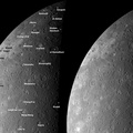
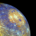
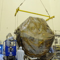
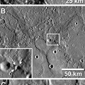
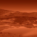
As MESSENGER approached Mercury, the NAC acquired images to create a mosaic of the entire planet. The mosaic shown here was created from about half of those images and is shown in an orthographic projection. This view is in contrast to the cylindrical equidistant map mosaic previously released. For this mosaic, an orthographic projection was used to create a view that has the perspective that one would see from deep space. Over three decades earlier, Mariner 10 viewed this portion of Mercury’s surface, and the craters that were named on the basis of those images are labeled on this mosaic. The MESSENGER images of this same territory are allowing scientists to study Mercury’s surface under different illumination conditions, and these complementary views provide new insight into the nature of the geologic features on Mercury.


Information
- Taken in
- Author
- NASA/Johns Hopkins University Applied Physics Laboratory/Carnegie Institution of Washington
- Description
-
As MESSENGER approached Mercury, the NAC acquired images to create a mosaic of the entire planet. The mosaic shown here was created from about half of those images and is shown in an orthographic projection. This view is in contrast to the cylindrical equidistant map mosaic previously released. For this mosaic, an orthographic projection was used to create a view that has the perspective that one would see from deep space. Over three decades earlier, Mariner 10 viewed this portion of Mercury’s surface, and the craters that were named on the basis of those images are labeled on this mosaic. The MESSENGER images of this same territory are allowing scientists to study Mercury’s surface under different illumination conditions, and these complementary views provide new insight into the nature of the geologic features on Mercury.
Date Acquired: January 14, 2008
Instrument:Mosaic created with images taken by the Narrow Angle Camera (NAC) of the Mercury Dual Imaging System (MDIS)
Resolution: 1.5 kilometers/pixel (0.93 miles/pixel)
Scale: This mosaic shows Mercury from the equator nearly to the northern pole, a distance of about one Mercury radius (2440 kilometers, 1516 miles)
- Created on
- Monday 7 July 2008
- Albums
- US SPACE PROGRAM / PROBES / MERCURY / MESSENGER / Annoted/Science
- Source link
- https://photojournal.jpl.nasa.gov
- Visits
- 20
- Rating score
- no rate
- Rate this photo
- License
- Public Domain
- Modified by WikiArchives
- No (original)
- Downloads
- 0
Powered by Piwigo