. The highest resolution images were obtained at a resolution of about 50 meters (165 feet) per picture element and are shown here in context at about 220 meters per picture element. The images were taken by the Solid State Imaging (SSI) system on NASA's Galileo spacecraft at a range of about 4700 kilometers (2900 miles) for the highest resolution images and less than 20000 kilometers (12,400 miles) for the lower resolution color images.
The Jet Propulsion Laboratory, Pasadena, CA manages the Galileo mission for NASA's Office of Space Science, Washington, DC.")
WIKIARCHIVES.SPACE
The Human Spaceflight Archive
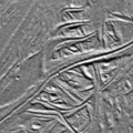
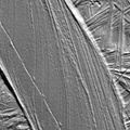
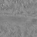
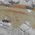
Agenor Linea is an unusually bright, white band on Jupiter's icy moon Europa. This mosaic uses color images to "paint" high resolution images of Agenor, and then places the colorized images within lower resolution images of the surrounding area. All data was obtained on September 26th, 1998 during the 17th orbit of Jupiter by NASA's Galileo spacecraft. Along this portion of Agenor is a "triple band," flanked by dark, reddish material of uncertain origin. On the right side of this image, Agenor splits into two sections. These color images will help scientists understand why Agenor Linea is unusually bright and white compared to Europa's other ridges and bands.


Information
- Taken in
- Author
- NASA/JPL-Caltech
- Description
-
Agenor Linea is an unusually bright, white band on Jupiter's icy moon Europa. This mosaic uses color images to "paint" high resolution images of Agenor, and then places the colorized images within lower resolution images of the surrounding area. All data was obtained on September 26th, 1998 during the 17th orbit of Jupiter by NASA's Galileo spacecraft. Along this portion of Agenor is a "triple band," flanked by dark, reddish material of uncertain origin. On the right side of this image, Agenor splits into two sections. These color images will help scientists understand why Agenor Linea is unusually bright and white compared to Europa's other ridges and bands.
North is to the upper right of the picture and the sun illuminates the surface from the east. The image, centered at 41 degrees south latitude and 189 degrees west longitude, covers an area approximately 135 by 60 kilometers (84 by 37 miles). The highest resolution images were obtained at a resolution of about 50 meters (165 feet) per picture element and are shown here in context at about 220 meters per picture element. The images were taken by the Solid State Imaging (SSI) system on NASA's Galileo spacecraft at a range of about 4700 kilometers (2900 miles) for the highest resolution images and less than 20000 kilometers (12,400 miles) for the lower resolution color images.
The Jet Propulsion Laboratory, Pasadena, CA manages the Galileo mission for NASA's Office of Space Science, Washington, DC.
- Created on
- Monday 7 December 1998
- Albums
- US SPACE PROGRAM / PROBES / JUPITER / GALILEO / Mission Photos (Edited) / JUPITER / EUROPA
- Source link
- https://photojournal.jpl.nasa.gov
- Visits
- 16
- Rating score
- no rate
- Rate this photo
- License
- Public Domain
- Modified by WikiArchives
- No (original)
- Downloads
- 0
Powered by Piwigo