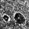
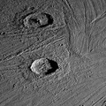
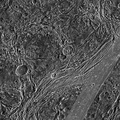
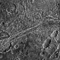
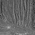
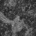
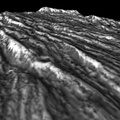
 in length and 17 to 20 km wide. On the floor of the inner depression is a lobate flow-like deposit 7 to 10 km wide with ridges that are curved outward (and apparently downslope) toward a cross-cutting lane of grooved terrain. The morphology of this structure suggests the possibility of volcanic eruptions creating a channel and flow, and cutting down into the surface.
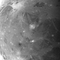
North is to the bottom of the picture and the sun illuminates the surface from the left. The mosaic, centered at 31 degrees south latitude and 189 degrees longitude, covers an area approximately 91 by 62 kilometers. The resolution is 172 meters per picture element. The images were taken on May 7, 1997 at 15 hours, 18 minutes, 35 seconds Universal Time at a range of 17,489 kilometers by the Solid State Imaging (SSI) system on NASA's Galileo spacecraft.
The Jet Propulsion Laboratory, Pasadena, CA manages the Galileo mission for NASA's Office of Space Science, Washington, DC.")
WIKIARCHIVES.SPACE
The Human Spaceflight Archive
NASA's Galileo imaging camera targeted an area in Sippar Sulcus on Jupiter's moon, Ganymede. Images obtained in 1979 by NASA's Voyager spacecraft showed that the area contained curvilinear and arcuate scarps or cliffs. These features appeared to be depressions which were candidate sources for some of the water ice volcanism thought to form the bright grooved terrain on Ganymede. The high resolution Galileo images seen here reveal that one of these structures contains a lobate, flow-like feature that is the best candidate yet seen for an icy volcanic lava flow on Ganymede. The prominent depression with scalloped walls and internal terraces is about 55 kilometers (km) in length and 17 to 20 km wide. On the floor of the inner depression is a lobate flow-like deposit 7 to 10 km wide with ridges that are curved outward (and apparently downslope) toward a cross-cutting lane of grooved terrain. The morphology of this structure suggests the possibility of volcanic eruptions creating a channel and flow, and cutting down into the surface.


Information
- Taken in
- Author
- NASA/JPL/Brown University
- Description
-
NASA's Galileo imaging camera targeted an area in Sippar Sulcus on Jupiter's moon, Ganymede. Images obtained in 1979 by NASA's Voyager spacecraft showed that the area contained curvilinear and arcuate scarps or cliffs. These features appeared to be depressions which were candidate sources for some of the water ice volcanism thought to form the bright grooved terrain on Ganymede. The high resolution Galileo images seen here reveal that one of these structures contains a lobate, flow-like feature that is the best candidate yet seen for an icy volcanic lava flow on Ganymede. The prominent depression with scalloped walls and internal terraces is about 55 kilometers (km) in length and 17 to 20 km wide. On the floor of the inner depression is a lobate flow-like deposit 7 to 10 km wide with ridges that are curved outward (and apparently downslope) toward a cross-cutting lane of grooved terrain. The morphology of this structure suggests the possibility of volcanic eruptions creating a channel and flow, and cutting down into the surface.
North is to the bottom of the picture and the sun illuminates the surface from the left. The mosaic, centered at 31 degrees south latitude and 189 degrees longitude, covers an area approximately 91 by 62 kilometers. The resolution is 172 meters per picture element. The images were taken on May 7, 1997 at 15 hours, 18 minutes, 35 seconds Universal Time at a range of 17,489 kilometers by the Solid State Imaging (SSI) system on NASA's Galileo spacecraft.
The Jet Propulsion Laboratory, Pasadena, CA manages the Galileo mission for NASA's Office of Space Science, Washington, DC.
- Created on
- Wednesday 15 July 1998
- Albums
- US SPACE PROGRAM / PROBES / JUPITER / GALILEO / Mission Photos (Edited) / JUPITER / GANYMEDE
- Source link
- https://photojournal.jpl.nasa.gov
- Visits
- 13
- Rating score
- no rate
- Rate this photo
- License
- Public Domain
- Modified by WikiArchives
- No (original)
- Downloads
- 3
Powered by Piwigo