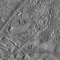
 system on board NASA's Galileo spacecraft during its sixth orbit of Jupiter. The upper portion of the image shows the southern extent of the wedges region, an area that has undergone extensive disruption. South of the wedges, part of Agenor Linea (nearly 1000 kilometers in length) is also visible. Agenor Linea is unique in that it is similar in width and length to the dark bands seen in the northern hemisphere, but it is bright in color rather than dark. This area will be studied at higher resolution on one of Galileo's later orbits, which should help scientists explain Agenor's bright color. This image can be used by scientists to make a global map of Europa by tying such Galileo images together with images from 1979 during NASA's Voyager mission. Such lower resolution images also provide the context needed to interpret the higher resolution images taken by the Galileo spacecraft during both its nominal mission and the upcoming Europa mission.
North is to the top of the picture and the sun illuminates the surface from the right. The image, centered at 40 degrees south latitude and 210 west longitude, covers an area approximately 675 by 675 kilometers. The finest details that can discerned in this picture are about 3.3 kilometers across. The images were taken on Feb 20, 1997 at 12 hours, 55 minutes, 34 seconds Universal Time when the spacecraft was at a range of 81,707 kilometers.
The Jet Propulsion Laboratory, Pasadena, CA manages the mission for NASA's Office of Space Science, Washington, DC.")
WIKIARCHIVES.SPACE
The Human Spaceflight Archive
This image of Europa's southern hemisphere was obtained by the solid state imaging (CCD) system on board NASA's Galileo spacecraft during its sixth orbit of Jupiter. The upper portion of the image shows the southern extent of the "wedges" region, an area that has undergone extensive disruption. South of the wedges, part of Agenor Linea (nearly 1000 kilometers in length) is also visible. Agenor Linea is unique in that it is similar in width and length to the dark bands seen in the northern hemisphere, but it is bright in color rather than dark. This area will be studied at higher resolution on one of Galileo's later orbits, which should help scientists explain Agenor's bright color. This image can be used by scientists to make a global map of Europa by tying such Galileo images together with images from 1979 during NASA's Voyager mission. Such lower resolution images also provide the context needed to interpret the higher resolution images taken by the Galileo spacecraft during both its nominal mission and the upcoming Europa mission.


Information
- Taken in
- Author
- NASA/JPL-Caltech
- Description
-
This image of Europa's southern hemisphere was obtained by the solid state imaging (CCD) system on board NASA's Galileo spacecraft during its sixth orbit of Jupiter. The upper portion of the image shows the southern extent of the "wedges" region, an area that has undergone extensive disruption. South of the wedges, part of Agenor Linea (nearly 1000 kilometers in length) is also visible. Agenor Linea is unique in that it is similar in width and length to the dark bands seen in the northern hemisphere, but it is bright in color rather than dark. This area will be studied at higher resolution on one of Galileo's later orbits, which should help scientists explain Agenor's bright color. This image can be used by scientists to make a global map of Europa by tying such Galileo images together with images from 1979 during NASA's Voyager mission. Such lower resolution images also provide the context needed to interpret the higher resolution images taken by the Galileo spacecraft during both its nominal mission and the upcoming Europa mission.
North is to the top of the picture and the sun illuminates the surface from the right. The image, centered at 40 degrees south latitude and 210 west longitude, covers an area approximately 675 by 675 kilometers. The finest details that can discerned in this picture are about 3.3 kilometers across. The images were taken on Feb 20, 1997 at 12 hours, 55 minutes, 34 seconds Universal Time when the spacecraft was at a range of 81,707 kilometers.
The Jet Propulsion Laboratory, Pasadena, CA manages the mission for NASA's Office of Space Science, Washington, DC.
- Created on
- Thursday 26 March 1998
- Albums
- US SPACE PROGRAM / PROBES / JUPITER / GALILEO / Mission Photos (Edited) / JUPITER / EUROPA
- Source link
- https://photojournal.jpl.nasa.gov
- Visits
- 15
- Rating score
- no rate
- Rate this photo
- License
- Public Domain
- Modified by WikiArchives
- No (original)
- Downloads
- 0
Powered by Piwigo