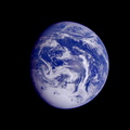
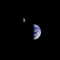
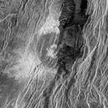
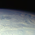
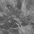
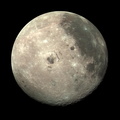
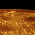
 by the Galileo spacecraft on December 9, 1992, as it left Earth en route to Jupiter. Visible are most of Egypt (left of center), including the Nile Valley; the Red Sea (slightly above center); Israel; Jordan, and the Arabian Peninsula. In the center, below the coastal cloud, is Khartoum, at the confluence of the Blue Nile and the White Nile. Somalia (lower right) is partly covered by clouds.")
WIKIARCHIVES.SPACE
The Human Spaceflight Archive


Information
- Author
- NASA/JPL-Caltech
- Description
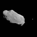
- This image of northeast Africa and the Arabian Peninsula was taken from an altitude of about 500,000 kilometers (300,000 miles) by the Galileo spacecraft on December 9, 1992, as it left Earth en route to Jupiter. Visible are most of Egypt (left of center), including the Nile Valley; the Red Sea (slightly above center); Israel; Jordan, and the Arabian Peninsula. In the center, below the coastal cloud, is Khartoum, at the confluence of the Blue Nile and the White Nile. Somalia (lower right) is partly covered by clouds.
- Created on
- Monday 29 January 1996
- Albums
- US SPACE PROGRAM / PROBES / JUPITER / GALILEO / Mission Photos (Edited) / EARTH
- Source link
- https://photojournal.jpl.nasa.gov
- Visits
- 243
- Rating score
- no rate
- Rate this photo
- License
- Public Domain
- Modified by WikiArchives
- No (original)
- Downloads
- 16
Powered by Piwigo