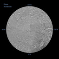
 per pixel. The resolution of the map is 64 pixels per degree. The mean radius of Dione used for projection of these maps is 350 miles (563 kilometers).
The northern maps are updates to the versions released in October 2010 (see PIA12815). There were no new data for the southern hemisphere, so the October 2010 versions of the southern maps (PIA12816) are unchanged.
The full unannotated tiff version can be downlinked here PIA14915_full_2.tif. The full annotated tiff version PIA14915_full.tif. Photojournal note: these are large images and may be too large for some web browsers to handle. Users may right-click on the links to download the files to their desktop.
The Cassini-Huygens mission is a cooperative project of NASA, the European Space Agency and the Italian Space Agency. The Jet Propulsion Laboratory, a division of the California Institute of Technology in Pasadena, manages the mission for NASA's Science Mission Directorate, Washington, D.C. The Cassini orbiter and its two onboard cameras were designed, developed and assembled at JPL. The imaging operations center is based at the Space Science Institute in Boulder, Colo.")
WIKIARCHIVES.SPACE
The Human Spaceflight Archive
The northern and southern hemispheres of Dione are seen in these polar stereographic maps, mosaicked from the best-available clear-filter images from NASA's Cassini mission.

Information
- Taken in
- Other
- Author
- NASA/JPL-Caltech
- Description
-
The northern and southern hemispheres of Dione are seen in these polar stereographic maps, mosaicked from the best-available clear-filter images from NASA's Cassini mission.
Each map is centered on one of the poles and surface coverage extends to the equator. Grid lines show latitude and longitude in 30-degree increments. The scale in the full-size versions of these maps is 502 feet (153 meters) per pixel. The resolution of the map is 64 pixels per degree. The mean radius of Dione used for projection of these maps is 350 miles (563 kilometers).
The northern maps are updates to the versions released in October 2010 (see PIA12815). There were no new data for the southern hemisphere, so the October 2010 versions of the southern maps (PIA12816) are unchanged.
The full unannotated tiff version can be downlinked here PIA14915_full_2.tif. The full annotated tiff version PIA14915_full.tif. Photojournal note: these are large images and may be too large for some web browsers to handle. Users may right-click on the links to download the files to their desktop.
The Cassini-Huygens mission is a cooperative project of NASA, the European Space Agency and the Italian Space Agency. The Jet Propulsion Laboratory, a division of the California Institute of Technology in Pasadena, manages the mission for NASA's Science Mission Directorate, Washington, D.C. The Cassini orbiter and its two onboard cameras were designed, developed and assembled at JPL. The imaging operations center is based at the Space Science Institute in Boulder, Colo.
- Created on
- Wednesday 23 May 2012
- Albums
- US SPACE PROGRAM / PROBES / SATURN / CASSINI/HUYGENS / MAPS / DIONE
- Source link
- https://photojournal.jpl.nasa.gov
- Visits
- 14
- Rating score
- no rate
- Rate this photo
- License
- Public Domain
- Modified by WikiArchives
- No (original)
- Downloads
- 0
Powered by Piwigo